Analysis · Race Comparison
The UTMB Ranks 119th for Elevation Density in Europe. Here Are 5 Races That Beat It.
The world's most famous trail race is not the world's hardest. The data makes the case — and so do five races most runners have never heard of.
Here's a number that will surprise most trail runners: 119.
That's where the Ultra-Trail du Mont-Blanc sits in the DiscoverTrailRaces database when ranked by elevation gain per kilometre — 119th of 389 European trail distances with GPS data. Not the hardest. Not the second hardest. Not even close to the top quarter. There are 118 races in Europe that pack more metres of climbing into every kilometre than the most famous trail race on the planet.
This isn't a takedown of the UTMB. It earns its reputation through other means — the depth of the competitive field, the volatility of August weather at altitude, 22 years of lore, and a course that is relentlessly non-flat (just 13.6% of its 174km runs level, ranking it 76th least-flat of 390 European distances). But "most famous" and "hardest" are not the same thing, and the data makes that distinction worth exploring.
Below are five races that make a credible case for being harder — and a verdict on how clean that case actually is.
The Baseline
UTMB — 174km · France / Italy / Switzerland
| Metric | UTMB 174km |
|---|---|
| Distance | 174 km |
| Elevation gain | 9,900m |
| Gain per km | 56.9 m/km |
| Gain/km rank (Europe) | 119th of 389 |
| % flat | 13.6% — rank 76/390 |
| Biggest single climb | 1,556m — rank 23/385 |
| Entry fee | €479 · €2.75/km |
| Entry system | Lottery |
| Cutoff | 47 hours |
| Countries | France, Italy, Switzerland |
| Field size | 2,500+ starters · 1,665 finishers (2025) |
| Founded | 2003 |

UTMB 174km — Top 3 climbs & descents · Source: DiscoverTrailRaces GPX data
The UTMB's biggest single climb — 1,556m — ranks 23rd of 385 European trail distances. The course almost never goes flat. The weather can turn in an hour. The field is the deepest in trail running. These are real difficulty multipliers that no ranking column captures. Keep them in mind as you read what follows.
Ultra Tour Monte Rosa — 170km, Switzerland / Italy
Grächen, Valais · September 2026 · Founded 2017 · Organizer: Lizzie Hawker
✓ Harder — not debatable| Metric | UTMR 170km | UTMB 174km |
|---|---|---|
| Distance | 170 km | 174 km |
| Elevation gain | 11,600m ↑ | 9,900m |
| Gain per km | 68.2 m/km ↑ | 56.9 m/km |
| Gain/km rank (Europe) | 49th of 389 ↑ | 119th of 389 |
| % flat | 12.5% — rank 56/390 ↑ | 13.6% — rank 76/390 |
| Biggest climb | 1,716m — rank 13/385 ↑ | 1,556m — rank 23/385 |
| Avg uphill gradient | 16.11% ↑ | 13.16% |
| 20%+ uphill km | 22.26 km ↑ | 16.89 km |
| Entry fee | CHF 340 (~€2.18/km) | €479 (€2.75/km) |
| Entry system | Vetting — mountain CV required | Lottery |
| Cutoff | 60 hours | 47 hours |
| Finishers (most recent) | ~135 (2025, cut short) | 1,665 (2025) |
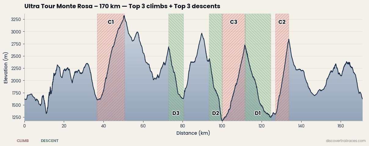
UTMR 170km — Top 3 climbs & descents · Note the baseline: the entire race runs above 1,500m. Peaks reach 3,300m+.
UTMR beats UTMB on every single gradient metric. It's shorter by 4km but gains 1,700m more. Look at the elevation profile and the baseline tells the story immediately — the entire 170km operates above 1,500m, with the route pushing to 3,300m+ on the high passes. UTMB drops back to valley floor multiple times. UTMR barely does.
The course circumnavigates the Monte Rosa massif through three countries and three languages — German-speaking Valais, French-Italian Aosta Valley, Walser culture in Piedmont — crossing a glacier that requires mandatory warm kit including a duvet jacket and thick gloves. In 2025, the race was stopped approximately 20km short of the finish because a rockfall blocked the Höhenweg trail to Grächen. The year before, temperatures at altitude dropped to -2°C with wind chill pushing to -10°C.
You don't enter UTMR by clicking a button in a lottery. Organizer Lizzie Hawker's volunteer team reviews your mountain experience before allowing payment. With 135 finishers in 2025, it's one-twelfth the size of the UTMB finish line. One reviewer described it as "by far the hardest race I've ever done, much harder than UTMB." The data supports that. On every metric that matters, UTMR wins.
Pirin Ultra — 160km, Bulgaria
Bansko, Pirin National Park (UNESCO) · September 2026 · Founded 2016
✓ Harder on paper. Arguably harder in practice.| Metric | Pirin Ultra 160km | UTMB 174km |
|---|---|---|
| Distance | 160 km | 174 km |
| Elevation gain | 11,000m ↑ | 9,900m |
| Gain per km | 68.75 m/km ↑ | 56.9 m/km |
| Gain/km rank (Europe) | 56th of 389 ↑ | 119th of 389 |
| % flat | 9.7% — rank 19/390 ↑ | 13.6% — rank 76/390 |
| Biggest climb | 1,673m — rank 15/385 ↑ | 1,556m — rank 23/385 |
| Biggest descent | 1,668m — rank 11/386 ↑ | 1,258m — rank 63/386 |
| Entry fee | €98 · €0.61/km ↑ | €479 · €2.75/km |
| Course marking | None. GPS file only. | Fully marked |
| Qualifies for | UTMB 100M + Hardrock 100 | N/A — is the final |
| Finishers (2024) | 87 | ~1,650+ |
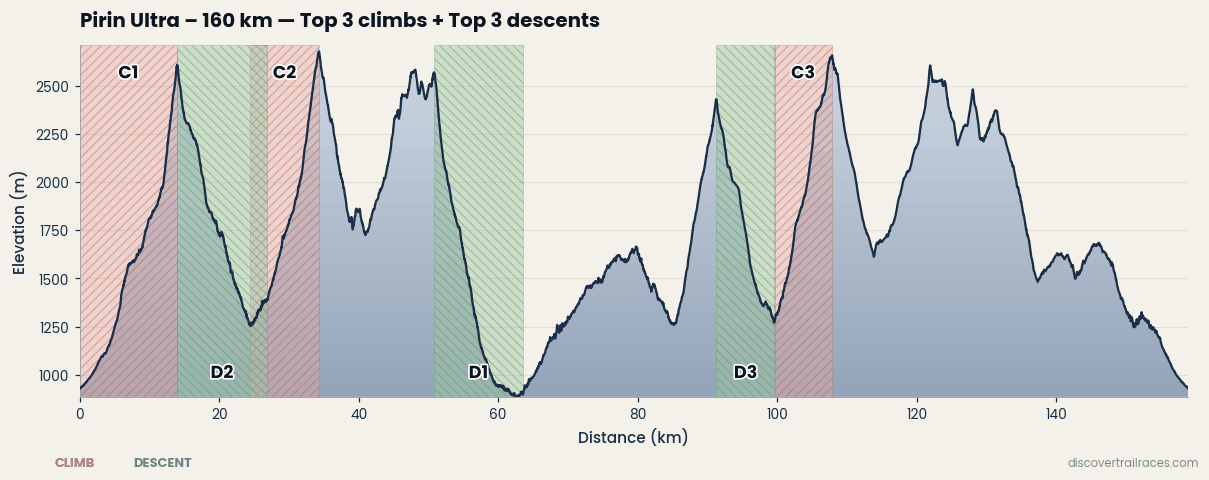
Pirin Ultra 160km — Top 3 climbs & descents · 9.7% flat: the 19th least-flat race of 390 tracked in Europe
Just 9.7% of the Pirin Ultra is flat — the 19th least-flat of 390 European trail distances tracked. The course is, effectively, split in two: climbing and descending, with almost nothing in between.
Here's what makes it genuinely different: there are no markings. No ribbons. No arrows. The course is not signed anywhere on 160km of high mountain terrain in a UNESCO World Heritage Park. You load the GPX file and navigate yourself. UTMB runners follow a corridor of hundreds of other runners and a fully marked route. Pirin Ultra runners are alone on a mountain in Bulgaria in September, navigating across marble ridge terrain near vertical rock walls, often in darkness.
The km 45–55 section — crossing exposed ridges with no water and proximity to near-vertical drops — is designated a specific safety zone by the organizers. A 50-hour cutoff guarantees every finisher experiences at least one full night on high-altitude terrain. It's a Hardrock 100 qualifier as well as a UTMB 100M race. Entry is €98 standard — €0.61 per kilometre for Hardrock-qualifying terrain. At the UTMB you're paying €2.75/km and still need to win a lottery. With 87 finishers in 2024, the field is intimate to the point of isolation.
Eiger Ultra Trail E250 — 250km, Switzerland
Grindelwald, UNESCO Jungfrau-Aletsch · July 2026 · Founded 2022
⚑ Most extreme numbers — but read the small print| Metric | Eiger E250 | UTMB 174km |
|---|---|---|
| Distance | 250 km ↑ | 174 km |
| Elevation gain | 18,000m ↑ | 9,900m |
| Gain per km | 72 m/km ↑ | 56.9 m/km |
| Gain/km rank (Europe) | 74th of 389 ↑ | 119th of 389 |
| Biggest climb | 1,757m — rank 20/385 ↑ | 1,556m — rank 23/385 |
| Biggest descent | Rank 10/386 ↑ | Rank 63/386 |
| Entry fee | ~€2.61/km | €2.75/km |
| Entry | Lottery — sold out | Lottery |
| Format | Teams of 2–3 runners only | Solo |
| Navigation | GPS required, no marking | Fully marked |
| Cutoff | 100 hours | 47 hours |
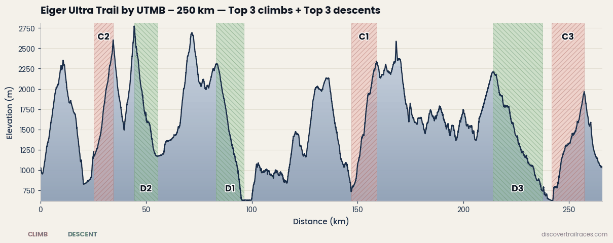
Eiger E250 250km — Top 3 climbs & descents · 18,000m total gain: the highest vertical of any race in this comparison
18,000 metres of elevation gain over 250 kilometres. 72 metres of climbing per kilometre. The biggest single descent in this entire comparison ranks 10th of 386 European trail distances. The Eiger E250 is operating in a different atmosphere from almost everything else in European trail running — and it does it in the shadow of the Eiger, Mönch, and Jungfrau, through the UNESCO Jungfrau-Aletsch World Heritage zone, on GPS navigation with no route marking.
The reason this sits third rather than first is one sentence: you cannot run the Eiger E250 alone. It's a team race — 2 to 3 runners required. What breaks a solo runner — isolation, sleep deprivation, decision-making at 3am — gets distributed across teammates. The 100-hour cutoff also softens the time pressure compared to UTMB's 47 hours.
The terrain is harder. The numbers are harder. The sheer weight of 18,000m of vertical is harder. Whether the team format makes the overall experience harder than UTMB solo is genuinely debatable — and that's the right question to sit with.
TihioRace Ultra Edition — 250km, Greece
Tihio, Central Greece · June 2026 · Founded 2020 · 3 UltraSummits
✓ Similar gradient density. Everything else is harder.| Metric | TihioRace 250km | UTMB 174km |
|---|---|---|
| Distance | 250 km ↑ | 174 km |
| Elevation gain | 14,000m ↑ | 9,900m |
| Gain per km | 56 m/km | 56.9 m/km |
| Biggest climb | 1,669m — rank 16/385 ↑ | 1,556m — rank 23/385 |
| Biggest descent | 1,456m — rank 25/386 ↑ | 1,258m — rank 63/386 |
| Entry fee | €220 · €0.88/km ↑ | €479 · €2.75/km |
| Entry | Open | Lottery |
| Aid stations | 8 over 250km · 38.5km max gap | Frequent, ~every 10–15km |
| Summit character | 3 summits — mountaineering terrain | High cols, no summits |
| Finishers | 18 (2025) · 10 (2024) | 1,665 (2025) |
| Founded | 2020 | 2003 |
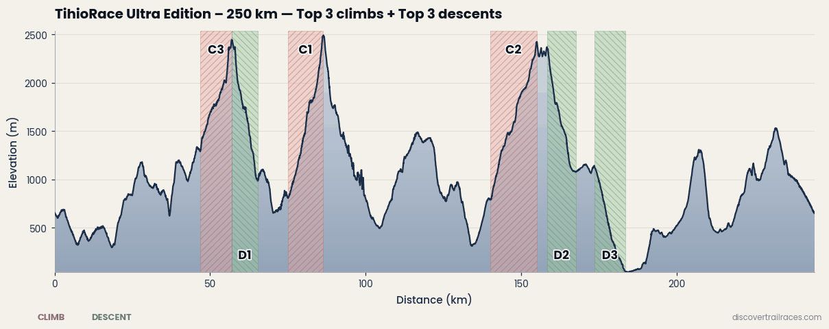
TihioRace 250km — Top 3 climbs & descents · Three summits above 2,400m: Vardoussia (2,495m), Giona (2,510m), Parnassos (2,457m)
On raw gradient density, TihioRace and UTMB are nearly identical — 56m/km vs 56.9m/km. But gradient density doesn't capture everything that makes a race hard.
TihioRace covers 250km across three summits in central Greece: Korakas on Vardoussia (2,495m), Pyramida on Giona (2,510m — described by the organizers as "purely mountaineering, no distinct trail, navigation by markers only"), and Liakoura on Parnassos (2,457m). There are 8 aid stations over 250km. The longest gap is 38.5km, running through the Reka gorge where the trail, per the official race guide, "is not always apparent… run on pebbles following the creek bed." There is a river crossing with no bridge at km 22. The route passes through the Delphi UNESCO archaeological site at km 177.
Only 18 people finished in 2025. 10 in 2024. Entry is €220 — €0.88 per kilometre. At the UTMB you're paying over three times that per kilometre, surrounded by 2,500 runners, with aid stations every 10–15km and full Chamonix race infrastructure. TihioRace gives you three Greek mountain summits, a gorge that may or may not have a visible trail, and 18 people at the finish line.
UTLAC — 254km, Italy
Lecco, Lake Como, Lombardy · May 2026 · Founded 2022
~ Debatable — longer and self-nav, but less elevation per km| Metric | UTLAC 254km | UTMB 174km |
|---|---|---|
| Distance | 254 km ↑ | 174 km |
| Elevation gain | 12,430m ↑ | 9,900m |
| Gain per km | 48.9 m/km | 56.9 m/km ← UTMB steeper |
| Avg uphill gradient | 11.72% | 13.16% ← UTMB steeper |
| % flat | 24.6% | 13.6% ← UTMB less flat |
| 20%+ uphill km | 14.04 km | 16.89 km |
| Entry fee | €535 · €2.11/km | €479 · €2.75/km |
| Navigation | GPS only, no marking | Fully marked |
| Finishers | 68 (2025) | 1,665 (2025) |
| Founded | 2022 | 2003 |
| Classification | UTMB 100M | UTMB World Series Final |
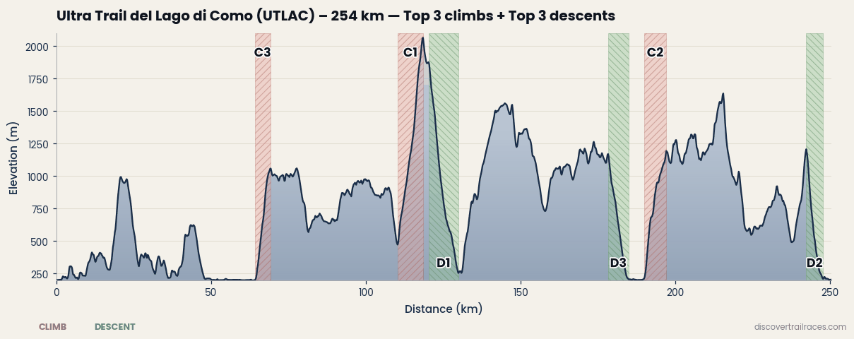
UTLAC 254km — Top 3 climbs & descents · The course starts at ~250m above sea level — far lower than the other races here — with 12,430m still to climb
The UTLAC is the one case on this list where the gradient data doesn't straightforwardly favour the challenger. At 48.9m per kilometre, UTLAC is actually slightly less elevation-dense than UTMB's 56.9m/km. The average uphill gradient (11.72%) is lower. The percentage of flat terrain is higher. On these numbers, UTMB is the steeper race.
So why is it here? Because the UTLAC's argument isn't gradient — it's everything else. 254km. Self-navigation across the sharp alpine limestone of the Larian Triangle with no course marking at any point. The biggest climb arrives at km 110: 8.16km averaging 19.5% gradient on limestone that punishes every imprecise footfall. A significant descent at 36.8% maximum gradient arrives with just 12km remaining — when the body is already 242km in.
UTLAC circumnavigates the entirety of Lake Como, starting and finishing in Lecco. The field draws from 47 nations. 68 people finished in 2025 — the race's fourth edition. Is it harder than UTMB? On raw gradient data, no. On the cognitive weight of self-navigation for 40–50+ hours across terrain that punishes any navigational error — it makes the case.
The Actual Verdict
Five races. Five different arguments. Here's how they stack up.
UTMR and Pirin Ultra are the cleanest cases. Both beat UTMB on every meaningful gradient metric. Both have smaller fields, less infrastructure, and higher technical demand. UTMR adds glacier crossings, vetting-based entry, and a course where the baseline altitude starts where UTMB's high points finish. Pirin adds GPS-only navigation on a Hardrock qualifier at €0.61 per kilometre.
Eiger E250 has the most extreme numbers on this list — 18,000m of gain, 72m per kilometre, rank 10 for the biggest single descent in European trail racing. The argument against: you share it with teammates. What destroys a solo runner gets distributed.
TihioRace is the sleeper case. The gradient data nearly matches UTMB, but the infrastructure gap is enormous. 18 finishers, mountaineering summits, a 38.5km aid gap, and €220 entry is a very different race from a €479 lottery event with 2,500 starters and full Chamonix infrastructure.
UTLAC is the most honest "debatable." The per-km numbers don't get there — UTMB is steeper. But 254km of self-navigation across sharp limestone for 40+ hours is not a shorter, easier race. It's a different kind of hard.
The UTMB remains the most competitive race on this list by a large margin. It's the World Series final for a reason. But if a runner asks "is this the hardest trail race in Europe?" — the data says no. There are at least five races that would disagree.
All gradient and elevation figures sourced from DiscoverTrailRaces GPX data (Airtable Distances table, 389 records, queried May 2026). Rankings are within European trail running distances with verified GPS data. Pool sizes: Top1Ascent 385 records · Top1Descent 386 records · D+/km and Percent-Flat 389–390 records.
Sources
- DiscoverTrailRaces Airtable — Distances table, 389+ GPS-verified records — queried 2026-05-14 to 2026-05-19
- Carnethy Running Club — Ultra Tour Monte Rosa 2025 race report — carnethy.com/2025/09/ultra-tour-monte-rosa-race-report/
- educatedguesswork.org — Ultra Tour Monte Rosa race report — educatedguesswork.org/posts/utmr/
- en.tihiorace.gr — Official TihioRace 3 UltraSummits race page
- pirinultra.com — Official Pirin Ultra race website
- ultratourmonterosa.com — Official UTMR race website
- montblanc.utmb.world — Official UTMB race website